-
Tours
-
-
- Domestic Tours
-
-
- Resorts
- Car Rentals
- Destinations
- Getaways
- Hotels
- Tools
- * Workation
- * Tour Plans
- Blog
- List Property
- * Offers *

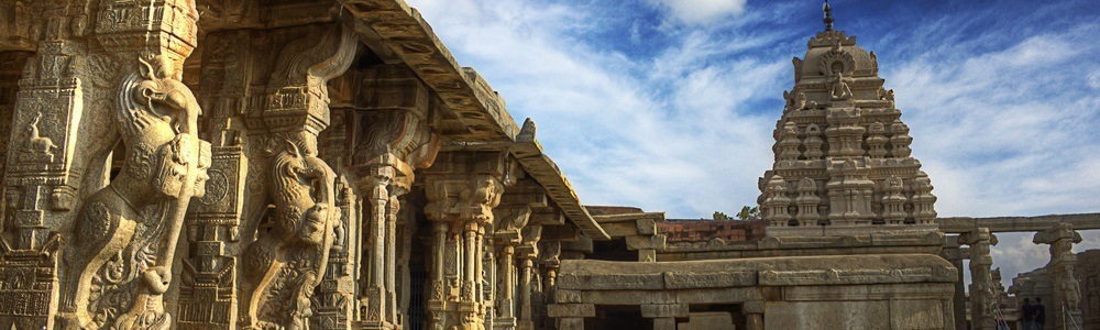

Ramappa Temple is a historical temple situated at Palampet village in the Warangal district of Telangana. About 65 km from Warangal, and 211 km from Hyderabad, it is one of the top heritage sites in India, and among the must-include places in Warangal tour packages.
Dedicated to Lord Shiva, Ramappa Temple or Ramalingeshwara Temple was built by General Recherla Rudra, during the period of the Kakatiya ruler Ganapati Deva in 1213 AD. The temple got its name from Ramappa, the chief sculptor of the temple. It's probably the only temple in the country to be known by the name of its sculptor, and among the popular places to experience Telangana Tourism. It has been conferred with a World Heritage Site status on 25th July 2021.
Stands on a 6 feet high star-shaped platform, the sandstone temple is crowned with a grand sikhara and is surrounded by a pradakshina path. The temple has12 sculptures of madanikas marvelously carved in different poses. Ramappa Temple is known for its architectural brilliance that gives us a glimpse of the technical innovations in the form of floating bricks, & sand-box foundations.
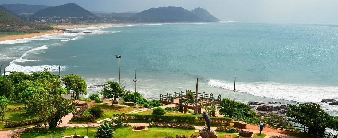
Distance from Vizag: 491 Kms

At a distance of 33 km from Guntur, 38 km from Vijayawada, 111 km from Machilipatnam, 162 km from Khammam, 178 km from Nalgonda, 178 km from Bhadrachalam, 194 km from Rajahmundry, 270 km from Nellore, 274 km from Hyderabad, 403 km from Vishakhapatnam, 450 km from Anantapur, Amaravati is a popular historical town situated on the southern bank of Krishna River in Guntur district of Andhra Pradesh. It is the new capital of Andhra Pradesh state and one of the popular pilgrimage sites for Hindus as well as Buddhists.
The town gets its name from Amareshwara or Amaravati temple, dedicated to Lord Shiva. The town has been mentioned in the Indian epics as Dhanyakataka and Andhranagari. It was also served as the capital of the Satavahanas, who ruled Andhra Pradesh from the 2nd century BCE to the 3rd century CE. Later it was ruled by several major dynasties like Andhra Ikshvakus, the Pallavas, the Cholas, the Kakatiyas, the Delhi Sultanate, Musunuri Nayaks, Bahmani Sultanate, Vijayanagara Empire, Sultanate of Golconda and Mughal Empire successively before the founding of the Nizam of Hyderabad in 1724. It was ceded to France in 1750 but was captured by England in 1759. It was briefly captured by Hyder Ali, but remained under British rule for the majority of time since the 1780s. Amaravati is currently the de-facto capital of the state of Andhra Pradesh, following its bifurcation from Telangana in 2014.
Amaravathi has gathered attention from all over the world because of the ...
Distance from Vizag: 363 Kms

At a distance of 198 km from Hyderabad, 128 km from Vijayawada and 119 km from Warangal, Khammam is a town and headquarters of Khammam district. Situated on the banks of Munneru River, a tributary of Krishna River, Khammam is one of the top Telangana tourist places.
Khammam derived its name from Stambadri, a hill on which an ancient Narasimha temple is built. Stambadri was called Kambam Mettu, which later changed to Kammamet and finally Khammam. Khammam district is known for its natural resources like coal and iron ore. It is also famous for its natural beauty. Godavari River flows through Khammam district touching Bhadrachalam. Khammam district is bordered with Bastar region of Chattisghar state which is core Dandakaranya forest area.
Khammam was ruled by several dynasties including Kakatiyas, Musunuri Nayaks and Velama kings, Reddy kings, Qutb Shahi and Nizams of Hyderabad. Khammam district has several tourist attractions like Bhadrachalam, Kinnerasani Dam & Sanctuary, Khammam Fort, Kusumanchi Temples, Nelakondaalli, etc.
Khammam is well connected by Road and Train from Hyderabad and Vijayawada. It is hardly 2 hours drive from Vijayawada and 3 hours from Hyderabad. Khammam also has excellent public transportation facility. The Khammam railway station lies between Hyderabad - Vijayawada line and has frequent train ...
Distance from Vizag: 407 Kms

At a distance of 36 km from Puri, 61 km from Bhubaneswar, 111 km from Ratanpur, 394 km from Rourkela, 408 km from Jamshedpur, 462 km from Vizag, 482 km from Raigarh and 522 km from Ranchi, Konark is a small town in Puri district of Odisha along the coast of Bay of Bengal. Renowned world over for the Sun Temple, Konark is one of the top tourist destinations in Odisha and also one of the popular places of heritage in India.
The name Konark is derived from two Sanskrit words - Kona meaning angle and Arka meaning sun, in reference to the temple which was dedicated to the Sun God. Also known as the Black Pagoda, the Sun Temple was built in black granite during the reign of Narasimhadeva-I. The temple resembles the mythical chariot of the Sun God and is a UNESCO World Heritage Site since 1984. The temple is now mostly in ruins, and a collection of its sculptures is housed in the Sun Temple Museum, which is run by the Archaeological Survey of India.
Konark Tourism presents a multitude of attractions that fascinate tourists from all over the world. Konark Beach, Ramachandi Temple, Kuruma, Astranga Beach, Varahi Devi Temple at Chaurasi and Maa Mangala Devi Temple at Kakatapur are some popular places to visit in Konark apart from Sun Temple. Konark was also one of the few places in India to experience a total solar eclipse.
Besides the magnificent Sun Temple, Konark is also famous for Konark Dance Festival. This five day long cultural extravaganza is one of the most ...
Distance from Vizag: 446 Kms

At a distance of 36 km from Araku, 88 km from Vizag & 662 km from Hyderabad, Borra Caves are one million year-old limestone caves and the deepest caves in the country. Situated in Anantagiri hills of Andhra Pradesh, the caves are situated at an altitude of 1400 m and occupy an area of 2 sq.km. Borra Caves is one of the best places to visit in Araku Valley as part of Vizag packages.
These natural caves were discovered in 1807 by William King George of the Geological Survey of India. According to locals, once a cowherd lost his cow while grazing. He soon realized that his cow had fallen down. While searching for the cow, the cowherd found these caves and came across a Linga inside it. The Linga is considered synonymous to Lord Shiva, who saved the cow. After this, a small Shiva temple was built right outside this cave.
The caves are filled with fascinating stalagmite and stalactite formations of calcium deposits. The Gosthani River used to flow through the caves between the formations. The caves were created due to the flow of river over the limestone area. The pressure was exerted by the humic acid in the water on the mineral deposits and the limestone dissolved in the water. The dissolved limestone trickled down drop by drop forming different shapes in the cave. One can see different formations of the stalactites and stalagmites as Shiv-Parvathi, Mother-Child, Rushi's Beard, ...
Distance from Vizag: 88 Kms

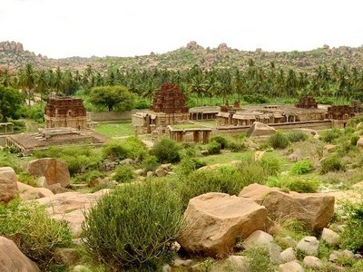
At a distance of 32 km from Guntur, 58 km from Amaravati and 73 km from Vijayawada, Kondaveedu Fort is an ancient hill fortress located at Kondaveedu village in Guntur district of Andhra Pradesh. It is one of the historical forts in Andhra Pradesh and among the famous Amaravati Tourist Places.
Kondaveedu Fort was constructed during the time of Telugu Chodas, strengthened by Kakatiyas and occupied by Prolaya Vema Reddy who shifted his capital from Addanki to Kondaveedu in 1323 AD. Later it was taken over by Gajpathis of Orissa and ravaged by the Bahmani Sultans in 1458. The Vijayanagara emperor Krishnadevaraya captured it in 1516. The Golconda Sultans fought for the fort in 1531, 1536 and 1579, and Sultan Quli Qutb Shah finally captured it in 1579, renaming it as Murtuzanagar. Later it was recaptured by the Mughal army of Aurangzeb in 1687 and the fort came under the control of the French colonists in 1752 when it was extensively fortified. It passed on to the English imperialists who got control of the fort in 1788 but abandoned it in the early 19th century in favour of Guntur.
There are two other forts nearby. All the three forts on top of the narrow hill range are now in ruins. At an altitude of about 1700 feet, the earliest one date back to 12th century and was considered then as one of the strongest forts in the region. It comprises huge ramparts, warehouses, granaries, and wells. There are two entry gates into the forts, called the 'Kolepalli Darwaza' and the ...
Distance from Vizag: 413 Kms

At a distance of 22 Kms from Vizag Railway Station & 620 Kms from Hyderabad, the Thotlakonda Buddhist Complex is situated on a hilltop in Chepala Uppadu village on Bheemili beach road (after Rishikonda).
Also known as 'the Hill of Eagles', the complex has a number of stupas, Chaityas, Viharas, a congregation hall and a refectory belonging to the Hinayana school, mostly excavated during1982-92. These remains are classifieds as religious, secular and civil. Excavations at Thotlakonda comprise pottery, beads, bangle pieces, tiles, stuccos, iron objects, sculptural remains, moulded bricks, inscriptions, coins, etc.
Distance from Vizag: 22 Kms

At a distance of 20 Kms from Vizag Railway Station & 618 Kms from Hyderabad, Bavikonda is historical Buddhist site near Kapula Uppadu village in Bheemili beach road (after Rishikonda).
The hill acquired the name Bavikonda due to the existence of wells on the hill to collect rain water for drinking purpose. The artifacts recovered here include Roman coins and satavahana coins apart from pottery dating back to 3rd century BC and 2nd Century AD. Excavations on the hill-top brought to light an extensive Buddhist establishment consisting of a Mahachaitya, stupas, chaityagrihas, a congregation hall, platforms, viharas, kitchen-cum-store complex, pottery, relic caskets, tiles, stuccos, iron objects, moulded bricks, coins etc
Distance from Vizag: 20 Kms
Similar Getaways
Domestic & International Cards Accepted