-
Tours
-
-
- Domestic Tours
-
-
- Resorts
- Car Rentals
- Destinations
- Getaways
- Hotels
- Tools
- * Workation
- * Tour Plans
- Blog
- List Property
- * Offers *


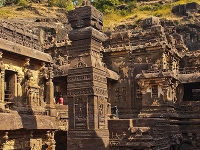
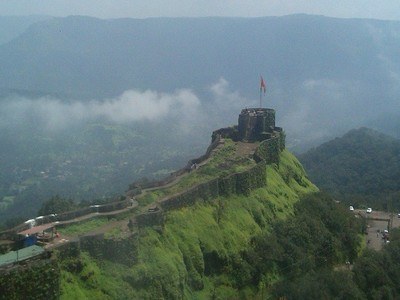
At a distance of 94 km from Pune Junction, Shivneri Fort is an ancient fort situated near Junnar in Pune district of Maharashtra. Shivneri Fort is one of the most magnificent as well as historically rich forts of India. It is a famous trekking destination and also a popular weekend picnic destination near Pune. It is also one of the top tourist places in Pune visiting.
The Shivneri Fort was built during the time of Satavahanas. After the Satavahanas, the Shivneri Fort was occupied by the Shilaharas, the Yadavas, and the Bahamanis. In 1599 AD the hill fort was granted to Shivaji's grandfather, Maloji Bhosale and passed down to Shahaji. Jijabai (Shivaji's mother) spent the days of her pregnancy here and this was the birth place of Shivaji, the famous Maratha warrior who was born in 1630 AD. Shivaji spent his childhood in Shivneri Fort and also undertook his military training here.
Shivneri is a triangular shape hill fort and has its entrance from the South-West side of the hill. Apart from the main gate there is an entrance to the fort from Eastern side called locally as the chain gate, where in one has to hold chains to climb up to the fort gate. The fort extends up to 1 mi with seven spiral well-defended gates. There are mud walls all around the fort. The fort also exhibits a small water pond named Badami Talav, located in the center of the fort. Close to the pond lies the idol of Jijabai along with her son Shivaji. Shiv Janmasthan, Ambarkhana, Kadelot Point, Ganga ...
Distance from Aurangabad: 230 Kms

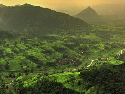
At a distance of 8 km from Khireshwar, 15 km from Malshej Ghat, 50 km from Bhandardara, 166 km from Pune & 218 km from Mumbai, Harishchandragad is a historical hill fort situated in Ahmednagar district of Maharashtra. It is one of the popular places of heritage in Maharashtra, and among the famous places to visit as part of Malshej Ghat packages.
Situated at an altitude of 1,424 m, the fort once played a major role in guarding and controlling the surrounding region. Among the most prominent tourist places in Malshej Ghat, the fort originally dates back to the 6th century during the rule of the Kalchuri dynasty. The citadel was built during this era and various caves probably have been carved out in the 11th century AD. Sage Changdev used to meditate here in the 14th century AD. Later the fort was under the control of Mughals and Marathas captured it in 1747 AD. Remnants of Microlithic human inhabitants have been discovered here. The fort of Harishchandragad has been mentioned in various Puranas like Matsya Purana, Agni Purana, and Skanda Purana.
Rohidas, Taramati, and Harishchandra are the three peaks in Harishchandragad. Taramati peak is the highest peak in the fort and provides a beautiful panoramic view of the nearby surroundings and the forest area. Many peaks and attractions ...
Distance from Aurangabad: 234 Kms

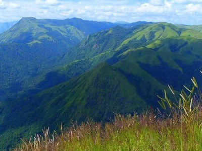
At a distance of 12 km from Bhandardara, 165 km from Mumbai & 174 km from Pune, Kalsubai Peak is a mountain peak in the Ahmednagar district of Maharashtra. This is one of the popular places of trekking in Maharashtra, and among the must include places in Bhandardara tour packages.
The peak of Kalsubai perched at an altitude of 5400 feet (1646 m) and it is the highest peak in Maharashtra. The peak lies within the Kalsubai Harishchandragad Wildlife Sanctuary. It is one of the best places to visit in Bhandardara for adventure enthusiasts. The peak is a small plateau and offers a commanding view of nearby forts and Bhandardara Dam. It was used for keeping watch on their enemies during the Maratha rule in the region. Kalsubai Temple is Located at the topmost peak of the Sahyadri mountain range of Maharashtra.
Mount Kalsubai is a famous trekking destination in Maharashtra. The trekking route attracts a large number of visitors, some to conquer the highest peak in Maharashtra, some trek to Kalsubai to visit Mandir and offer prayers to local deity Kalsubai. The temple houses an old well, where the water level never drops below 3 feet. A religious fair is organized by the locals at this temple during Navratri.
To reach the summit there are various trekking routes. The ...
Distance from Aurangabad: 223 Kms

At a distance of 6 km from Ratanwadi, 23 km from Bhandardara, 183 km from Pune & 197 km from Mumbai, Ratangad is an ancient hill fort situated at Ratanwadi village in Ahmednagar district of Maharashtra. It is one of the best forts in Maharashtra and an ideal place for trekking around Mumbai & Pune.
The Ratangad Fort is one of the most popular places to visit in Bhandardara and the place leaves visitors spellbound with its rich heritage. The fort is located at a height of 4250 feet. Ratangad Fort is 400 year old fort, which was used by Maratha warrior Shivaji. The fort was initially ruled by the Mughals and it was conquered by Shivaji Maharaj.
Ratangad has a natural rock peak with a cavity at the top which is called Nedhe or Eye of the Needle. The fort has four gates known as Ganesh, Hanuman, Konkan and Trimbak. There are two caves on the Ratangad Fort, one of the caves is smaller and can accommodate 8-10 people, while the other cave is larger and can accommodate 40-50 people. It also has many wells on the top. The base village Ratanwadi has Amruteshwar Temple which is famous for its carvings. The Pravara River originates in Ratangad Fort. According to the local legend, Sage Agastya meditated and performed penance in Ratangad. At that place two drops of Amrut was dropped and water started flowing out from Ratangad continuously resulting in the river Pravara hence the name 'Amrutvahini'.
There are numerous ...
Distance from Aurangabad: 215 Kms

At a distance of 48 km from Malshej Ghat, Ajoba or Ajaparvat is one of the highest peaks in the Sahyadri ranges of the Western Ghats in Maharashtra. Situated near Dehene village, it is one of the popular places of trekking near Mumbi and among the best places to visit as part of Malshej Ghat Packages for adventure enthusiasts.
Standing at a height of over 4,511 feet, Ajoba Hill is one of the highest peaks in the Western Ghats. Midway to the fort lies Valmiki Ashram which is believed to be the place where Valmiki wrote the epic 'Ramayana'. According to the legend, this is the place where Goddess Sita was said to be staying after being separated from Lord Rama. Carvings on the Ashram wall depict stories of Gods and Goddesses. The fort was named 'Ajobagad' after the great sage Valmiki who was called 'Ajoba' or grandfather by Luv and Kush.
Nestled amidst thick greenery, the Ajoba Hill Fort is a delight for trekkers as it presents an exciting trail to the top. People interested in rock climbing also come here to feel the adrenaline rush. The trek to the Ajoba hill starts from the Dehene Village. The trek is in two halves where the first half is till the Valmiki Ashram which is a leisure walk through the sacred forest with rich flora and fauna. There are some carved stones and a small hut near the ashram where one can stay. A little downhill from the Ashram lies a mountain stream carrying clear potable water. While, the second half of the trek is to Luv Kush Cave from Nalichi ...
Distance from Aurangabad: 274 Kms

At a distance of 13 km from Malshej Ghat, Sindola or Shindola Fort is a small hill fort situated on top of Malshej Ghat Plateau. It is one of the wonderful places of trekking near Pune and among the famous places to visit in Malshej Ghat.
Situated at an altitude of 1128 feet, Sindola mountain is distinct by its pinnacle structure visible from anywhere. Sindola is more of a sort of military base as it offers a whole view of Malshej and the Pargaon region and all of its neighboring forts. Sindola dates back very old at similar times of Nimgiri and Hadsar. Sindola fort is a small fort. Ruins of bastions & only a couple of water cisterns and idols of Ganesh are present on the top.
Sindola is one of the popular trekking places in Malshej Ghat and is a one day trek. There are 3 base villages from where one can start the trek to Sindola Fort. The trek that starts from Karanjale village, is one of the best and popular routes. Bagadwadi at Pargaon is the other starting point of Sindola Fort trek. Karanjale is situated on Kaylan-Malshej-Alephata Highway in between Khubi phata & Velkhind. It is about 2 km from Malshej Ghat Bus Stop at Khubi Phata. The route starts from the fields opposite the signboard of Karanjale village. The 2.5 km trek route is pretty straight forward and easy to moderate climb (monsoon). The route is not marked but is quite distinct as one has to go up and reach Sindola plateau, the start point of the ridge. Climb to the ridge can be started from any ...
Distance from Aurangabad: 231 Kms

At a distance of 30 km from Malshej Ghat, Naneghat is a mountain pass in the Western Ghats of Maharashtra, India. Situated on Kalyan - Ahmednagar Highway near Vaishakhare village, it is one of the wonderful places of trekking in Maharashtra, and among the mus visit places as part of Malshej Ghat tour for adventure lovers.
Situated at an altitude of 2,600 feet, Naneghat, also referred to as Nanaghat or Nana Ghat was a part of an ancient trading route during the reign of the Satavahana (c. 200 BCE - 190 CE). It connected the Konkan coast communities with Deccan high plateau through Junnar. This path was used as a tollbooth to collect toll from traders crossing the hills hence the name Nane Ghat where the word nane means 'coin' and ghat means 'pass'. It is one of the most famous Malshej Ghat tourst places.
The ghat is famous for a huge cave with Middle Indic inscriptions in Brahmi script. These inscriptions have been dated between the 2nd and the 1st century BCE and attributed to the Satavahana dynasty era. There is a temple of Ganesha on the other side of the pass. One can also see a huge rock-cut pot which was used presumably to collect coins from the traders passing by. There are many rock-cut water cisterns along the pass. The entire path of the Nane Ghat has stone ...
Distance from Aurangabad: 295 Kms

At a distance of 2 km from Naneghat and 32 km from Malshej Ghat, Jivdhan Fort is a hill fortress located near Malshej in Maharashtra. Situated near Naneghat, it is one of the historical forts in Malshej Ghat and among the popular trekking places near Pune.
Situated at a height of about 3,757 feet in the Sahyadri Mountain range, Jivdhan Fort is a part of the 'Famous 5' forts near Pune. The other four being the Chavaand, Hadsar, Shivneri, and Naneghat. As per the history, Jivdhan Fort dates back to the Satavahana era and has been a significant fort throughout history due to its proximity to the historic Naneghat. Jivdhan Fort guarded this route, which was a strategic location for many kingdoms. The Mughals imprisoned Murtaza, the last ruler of Adilshahi of Ahmednagar, at Jivdhan Fort. In 1635 Shahaji Bhosle, the father of Chhatrapati Shivaji Maharaj freed him from the prison and declared him the king of Ahmednagar. The fort was sacked and plundered by the British upon siege between 1815 and 1818.
Although the fortifications have crumbled down, one can see a huge storehouse or Kothi, which has was used to store grains. Besides the storehouse, there are several interesting ruins and remnants, including a few water cisterns and a temple dedicated to Goddess Jivai, who is supposed to be the patron deity of the fort. The fort's Northern bastion is in a pretty good condition even today. One can also see a few cisterns and remnants of old buildings near this bastion. From this ...
Distance from Aurangabad: 250 Kms

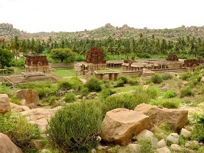
At a distance of 10 km from Igatpuri, 50 km from Nashik, and 54 km from Trimbakeshwar, Tringalwadi Fort is located at Tringalwadi village in Igatpuri taluka of Nashik district. It is one of the most popular places to visit as part of places to visit in Igatpuri.
Located at an elevation of 3000 feet, the Tringalwadi Fort is one of the must include places in Igatpuri tour packages. The presence of the caves indicates that the caves and the fort might be constructed around the 10th century. The fort was built to overlook the trade route which connected Konkan to the Nashik area. There is no evidence regarding the period during which it was under the control of Marathas, however, during the year 1688 AD Mughals took control over the fort. It is one of the 17 forts which were surrendered to the British in 1818 AD.
The fort attracts hikers and trekkers mainly during the monsoon. The top of the fort looks like a turban and overlooks the entire mountain range. At the foothills of the fort is a cave with beautifully carved entrance and a stone idol of Rishabhanatha in the sanctum. The cave has a large sabha mandapa. The fort also has a small Hanuman temple. One can see the ruins of old buildings and a small Bhavanimata temple on the fort. From the fort, travelers can also have a view of the Kalsubai and Kulang mountain ranges.
The village ...
Distance from Aurangabad: 232 Kms

At a distance of 22 km from Trimbakeshwar and 45 km from Nashik, Harihar Fort or Harihargad is a small hill fort in Upper Vaitarana range near Trimbak in Nashik district of Maharashtra. Also known as Harshgad or Harishgad, the fort is one of the popular monsoon trekking places near Nashik.
Harish Fort was one of the forts in the possession of the Ahmadnagar Sultans. It was visited by Captain Briggs in 1818 AD. In 1636 CE, Harishgad, Trimbakgad, Tringalwadi and few other forts were given by Shahaji to the Mughals. Harishgad was one of the 17 strong places that surrendered to the British on the fall of Trimbak in 1818 CE.
Situated at an altitude of 1120 m (3676 feet), Harihargad lies on a triangular rock with all the three sides vertical and is approachable only from one side i.e. through 200 feet high rock cut staircase. The most fascinating aspect about this trek is the rock cut steps at an angle of 80 degrees that one has to negotiate to enter the fort. Though it is a vertical ladder, the steps are provided with niches for proper grip while ascending. There are 117 steps in all. Ascending and descending through this patch is a thrilling experience.
After climbing up this first set of stairs one can reach the entrance of the fort also called the Darwaja. There is a very narrow path after this which needs to cover very carefully. Again one has to climb 100 steep stairs to reach the top of the fort. The fort has got a tapering plateau with a raised level in ...
Distance from Aurangabad: 230 Kms
| Package | Duration | Starting Price | Details |
|---|---|---|---|
| Ellora Caves- Ajanta Caves - Aurangabad | 3D/2N | ₹ 8700 | View Details |
| Mahabaleshwar - Lonavala | 4D/3N | ₹ 12250 | View Details |
| Mahabaleshwar - Alibaug | 4D/3N | ₹ 12150 | View Details |
| Nashik - Shirdi - Ajanta - Ellora - Aurangabad | 5D/4N | ₹ 14050 | View Details |
| Mahabaleshwar - Alibaug - Lonavala | 5D/4N | ₹ 15150 | View Details |
| Best of Konkan in 6 Days | 6D/5N | ₹ 18350 | View Details |
Similar Getaways


Domestic & International Cards Accepted