-
Tours
-
-
- Domestic Tours
-
-
- Resorts
- Car Rentals
- Destinations
- Getaways
- Hotels
- Tools
- * Workation
- * Tour Plans
- Blog
- List Property
- * Offers *
At a distance of 14 km from Nathula Pass, 22 km from Tsongmo Lake and 60 km from Gangtok, Menmecho Lake is a mountain lake situated at Kupup in East Sikkim district. Lies on the way to Jelep La Pass and ahead of the Tsomgo Lake, Menmecho Lake is considered as one of the most famous lakes of Sikkim and among the most beautiful high altitude lakes in India.
Surrounded by lush forests and mountains, Menmecho Lake is situated at an altitude of 12,500 feet. The lake is fed by the waters of the surrounding mountains of Jelep La Pass and it is the source of the River Rangpo Chu, a tributary of Teesta River. Known for its scenic beauty, the lake is said to be change colors every minute and stays frozen during the winter months. There is a viewpoint on the banks of the lake for the trekkers to rest and watch the beauty of the lake unfold before them.
Apart from its mystic beauty, Menmecho Lake is also famous for its trout fishing. The lake is one of the best trout cultivation centers of Sikkim and the Fisheries Department even maintains a cottage here. Anglers from various corners of the country as well from other parts of the world throng to lake and satisfy their love for adventure or game fishing. Special permits are required to reach this cottage and the lake because the road leading to this lake is guarded by the Indian Army. The permit can be obtained from the Police through a Sikkim Government authorized Tour Operator.
One can reach by hiring a cab or renting ...
At a distance of 19 km from Chopta Valley, 24 km from Thangu, 51 km from Guru Dongmar Lake and 59 km from Lachen, Muguthang Valley is a mountain valley situated to the east of famous Chopta Valley near Lachen. It is one of the popular places of trekking in Sikkim and among the must visit places in Lachen.
Also called as Lhonak Valley, it is situated at an elevation of 14,850 feet and can be reached by trekking from the Chopta Valley. This valley is normally uninhabitable except for some occasional settlements by Tibetan nomads for grazing their Yaks. This high mountain valley is basically under the constant vigil of Indian Army as this is the last outpost of Indian Army in the eastern part of extreme North Sikkim. From here they monitor the Nepal-Tibet border.
Lhonak Valley is a trans-Himalayan grassland in the exposed river valley of Goma Chu in northwest Sikkim, with boggy marshes, glacial lakes, barren scree slopes and glaciers. High alpine valley of Muguthang is only inhabitable for rare high altitude ruminants and their predators. Lakes and marshes here are used as stopover sites for migratory water birds. Muguthang is also popular for the annual Yak race which takes place during the festival of DrukpaTeshi.
Muguthang Valley can be reached from Chopta Valley by trekking through the high 5,900 m pass, the Lhonak La. This trek provides a fantastic view of glaciers, clear lakes, and rare flora. This 12 km trek starts from Kalapathar where the vehicular side ...
At a distance of 11 km from Namchi and 16 km from Ravangla, Tendong Hill is vantage point situated near Namchi in Sikkim. Situated above the Damthang, it is one of the must visit places in Namchi and among the popular trekking places in South Sikkim.
Situated at an altitude of 8530 feet, Tendong Hill provides a spectacular view of mountains and its surrounding plains. The literal meaning of 'Tendong' is 'the upraised horn' in Lepcha language. As per the local folklores, once flood hit the place and it is believed that the land here upraised itself to save the people. Even now, the Hill is regarded as a benefactor and people pray to the hill in the rainy season, to keep them away from the calamity of flood always. It has been a place of meditation for Buddhist Lamas, who spent years in meditation in the quiet and peaceful environment of the place.
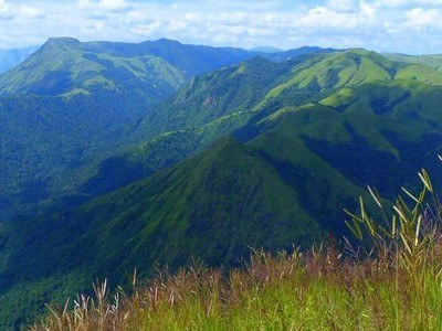
This hill is a celebrated landmark for trekkers and nature lovers. The Hill is encircled by dense forests, which abodes blossoming tress like that of magnolia and rhododendron. There is a small monastery and a three storied watch tower at the top. From the watch tower one can get the 360 degree view of the Singalila range in the west, Chola range in the east, part of Gangtok town, Nathu La, Darjeeling and part of the plains of West Bengal.
Tendong Hill can only be reached by trekking and the route starts from Damthang. The span of the trek is around 6 km which passes through thick green vegetation, rich in flora ...
At a distance of 12 km from Ravangla, Maenam Hill is a hill situated inside the Maenam Wildlife Sanctuary in Ravangla, Sikkim. It is one of the popular places of trekking in Sikkim and among the best places to visit in Ravangla.
Situated at an altitude of 10,300 feet, the scenic view from the hill is unmatched. Mt. Khangchendzonga and its surrounding ranges loom above to dwarf the richly forested and rugged hills. On a clear sunny day, it is possible to see the plains of Bengal spanning across Kalimpong and Darjeeling hills in the South and right across the Indo-China border towards the North.
The trek starts at an altitude of 7000 feet (2133 m) from Ravangla and goes up to 10,500 feet (3200 m). It is around 12 km trek (one way) that starts from Ravangla and takes around 4 hours to climb up and 2 hours to climb down. The path of the trek is really steep and the trek trail goes through Maenam Wildlife Sanctuary where one can spot rhododendron, oak, chestnut and magnolia trees. Red Panda, Himalayan Black Bears and different varieties of deer are also can be seen in the sanctuary. One can see 4 resting points on the way and an abandoned monastery at the top of the Maenam hill.
Another 1.5 km uphill trek leads to the legendry Bhaley Dunga, a kind of rocky spur which juts out from the ridge top and remains suspended in the air above Yangyang village. The path to Bhaledunga passing through Maenam La and it takes 1 hour. One can complete the whole trek in one day ...
At a distance of 25 km from Ravangla and 28 km from Pelling, Rangit Water World is an amusement park situated at Legship in Sikkim. Situated near the Rangit Dam, it is one of the popular places for adventure lovers and among the best places to visit in Ravangla.
Rangit Water World is a lake formed out of the waters from Rangit Dam, present amidst scenic settings. The water world was an initiative taken up by the local inhabitants of Legship. The lake is situated right on the main river bed between the cliffs. Rangit Dam is a Hydel project that was recently installed by National Hydel Power Corporation (NHPC).
Situated close by Legship, the place has gained immense popularity amongst the adventure enthusiasts to indulge into the activities like river rafting, angling and swimming. Its thrilling beauty nurturing in the lap of soul soothing surroundings makes it a perfect spot for the family picnics as well. One can also visit Kirateshwar Mahadev Temple, Legship Hot Springs and Lho Khando Sang Pho Caves at Legship.
Timings: 9 AM - 6.30 PM
At a distance of 122 km from Gangtok, Kangchendzonga or Kanchenjunga National Park is a National Park and a Biosphere reserve located in Sikkim, India. Also called as Khangchendzonga Biosphere Reserve, it is one of the largest wildlife reserves in Sikkim and among the best national parks in India.
At an altitude ranging from 1800 m to 8600 m, Kangchendzonga National Park is one of the few high altitude biosphere reserves in the country. The park was established in 1977 and was inscribed to the UNESCO World Heritage Sites list in 2016, becoming the first 'Mixed Heritage' site of India. The Khangchendzonga National Park includes a unique diversity of plains, valleys, lakes, glaciers and spectacular, snow-capped mountains covered with ancient forests. The third highest peak in the world, the Khangchendzonga, straddles the western boundary of the park, from which the reserve gets its name. The reserve also includes the vast Zemu Glacier.
The term Kanchenjunga literally means 'the Abode of Gods consisting of Five Treasure Houses'. These five treasure houses imply the five lofty peaks of Mount Kanchenjunga including Mount Narshing, Mount Pandim, Mount Siniolchu, Mount Simvo and Mount Kabru. The first three peaks are the most beautiful amongst all of them and stand tall in the park. Spread across an area of 850 sq. km, the area of the park starts from the cold deserts of the Lhonak Valley and the Lachen ridges to Yuksom. Situated in such an inaccessible expanse in the ...
Similar Getaways